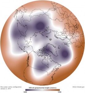
If you’ve been visiting or living in the United States at all this Winter, chances are you’ve heard of the polar vortex and the havoc its wreaking on most of the nation. Temperatures in the midwest plunging well below 0 degrees fahrenheit, an unusually cool southeast, frigid air along the eastern seaboard. And given the association of “polar” with “cold”, and “vortex” with “something disastrous”, it makes sense that the label would stick. But “polar vortex”, is a sensationalist term that makes one wonder if the media knows what a polar vortex actually is.
John Timmer at Ars Technica elucidates the misunderstood concept of the polar vortex. The polar vortex, he says, is simply a jet stream that contains that cold arctic air within, well, the arctic. During the wintry months, the arctic sees less sun, and atmospheric temperatures fall as a result. This creates something called a temperature gradient between the cold arctic air to the north and the warmer air of the south. An effect of the temperature gradient is a pressure gradient. Pressure gradients produce high winds along that north (cold) and south (warm) meeting point. These fasts winds are known as jet streams. The jet stream that circles the arctic is known as the polar vortex. The polar vortex acts as a sort of border, trapping the cold air in the arctic regions. In fact, if you ever look at a picture of it, you see that the polar vortex is located far north. Generally, unless you like cold air, you want that polar vortex to be strong in order to keep the cold air away from you.

But any time we hear the weather reports, we are bombarded with messages about how “the polar vortex is gripping the nation.” Why? Well, they kind of have the idea backwards. The Ars Technica article explains why a strong polar vortex is desirable, because it keeps the cold air north. So what the United States is currently experiencing is a weakened polar vortex. So technically, we are experiencing the temperatures associated with polar vortices, but this one is particularly weak.
Global warming seems to be the culprit for this excessive cold. Though that thinking may be counter intuitive, there are several reasons why a warmer climate could be the culprit:
1) Decreased snow and ice cover leave dark water and stretches of land exposed, which will absorb sunlight
2) Due to rapidly melting snow and ice, more water vapor is ascending into the atmosphere, i.e. more clouds. In the dark arctic winter, clouds insulate the arctic and the resulting condensation releases heat into the atmosphere.
Jet streams then meander, and this movement weakens the wind all together, causing the jet stream to move slowly. It’s like cold air is being locked into place. And that’s what we’re experiencing.
This is but one explanation, but the scientist behind it all, Jennifer Francis, has noted there has been no one to produce “contrary evidence”.